Hurricane Camille
| Category 5 hurricane (SSHS) | ||
|---|---|---|
 Hurricane Camille in the Gulf of Mexico |
||
| Formed | August 14, 1969 | |
| Dissipated | August 22, 1969 | |
| Highest winds |
|
|
| Lowest pressure | ≤ 905 mbar (hPa; 26.72 inHg) | |
| Fatalities | 259 direct[1] | |
| Damage | $1.42 billion (1969 USD) $8.5 billion (2010 USD) |
|
| Areas affected |
Cuba, Alabama, Mississippi, Louisiana, Southern United States, East-Central United States | |
| Part of the 1969 Atlantic hurricane season |
||
Hurricane Camille was the third and strongest tropical cyclone and second hurricane during the 1969 Atlantic hurricane season. The second of three catastrophic Category 5 hurricanes to make landfall in the United States during the 20th century (the others being 1935's Labor Day hurricane and 1992's Hurricane Andrew), which it did near the mouth of the Mississippi River on the night of August 17, Camille was the only Atlantic hurricane to exhibit officially recorded sustained wind speeds of at least 190 miles per hour (310 km/h) until Allen equaled that number in 1980, and remains the only Atlantic hurricane in recorded history to make landfall with wind speeds at or above such level. By central pressure, in turn, Camille was the second strongest U.S. landfalling hurricane in recorded history, second only to the Labor Day Hurricane in 1935.
The storm formed on August 14 and rapidly deepened. It scraped the western edge of Cuba at Category 3 intensity. Camille strengthened further over the Gulf of Mexico and made landfall with a pressure of 905 mbar (hPa), estimated sustained winds of 190 mph (305 km/h), and a peak official storm surge of 24 feet (7.3 m); by maximum sustained wind speeds, Camille was the strongest landfalling tropical cyclone recorded worldwide, and one of only four tropical cyclones worldwide ever to achieve wind speeds of 190 miles per hour (310 km/h). The hurricane flattened nearly everything along the coast of the U.S. state of Mississippi, and caused additional flooding and deaths inland while crossing the Appalachian Mountains of Virginia. In total, Camille killed 259 people and caused $1.42 billion (1969 USD, $8.51 billion 2011 USD) in damages. To this day, a complete understanding of the reasons for the system's power, extremely rapid intensification over open water and strength at landfall has not been achieved.
Contents |
Meteorological history
The origins of Hurricane Camille were from a tropical wave off the western coast of Africa on August 5. It tracked nearly due westward, eventually becoming clearly identifiable on satellite imagery on August 9. By that time, the thunderstorm activity concentrated into a circular area of convection. The next day, it moved through the Lesser Antilles, although there was no evidence of a closed circulation. On August 13, the wave passed near or over the southern coast of Jamaica as its convection spread northeastward through the Bahamas. Subsequently it began a slower motion to the northwest. On August 14, the Hurricane Hunters flew to investigate for a closed circulation near the Bahamas as well as near the Cayman Islands.[2] The crew observed a developing center in the western Caribbean, and winds quickly reached tropical storm status. It is estimated Tropical Storm Camille developed late on August 14 with winds of 60 mph (95 km/h), about 50 miles (80 km) west-northwest of Grand Cayman.[2][3]
Upon first being classified as a tropical cyclone, Camille was located in an area favorable for further strengthening, although initially it slowly intensified. It was located within an area of very light wind shear and an overall warm environment. Additionally, the storm developed strong low-level inflow from the deep southern Caribbean, which continuously brought moisture into the storm.[2] Throughout its duration, it was a small tropical cyclone, although with a radius of gale force winds spreading 100 miles (160 km) to the north, the storm's thunderstorm area quickly spread over Cuba. As the storm approached the western coast of Cuba, it began rapid deepening, reaching hurricane status and less than 12 hours later attaining major hurricane status, or winds of 115 mph (185 km/h). Prior to landfall, its eye was tracked by radar from Havana; it is estimated the hurricane moved ashore between Cape San Antonio and Guane late on August 15 as a major hurricane. Camille was a small hurricane as it crossed western Cuba, and its winds decreased to 105 mph (170 km/h) before it emerged into the Gulf of Mexico.[3]
Initially, Hurricane Camille was forecast to turn northeastward toward the Florida panhandle. Instead, it continued northwestward and rapidly intensified. Its eye contracted to a diameter of less than 8 miles (13 km), and strong rainbands developed around the entire hurricane. Due to the small eye, Hurricane Hunters at first had difficulties in obtaining the strength; however a flight late on August 16 recorded a very low pressure of 908 mbar, with winds estimated at 150 mph (240 km/h).[2] At the time, it was not expected to intensify further.[3] However, a subsequent Hurricane Hunters flight early on August 17 recorded a pressure of 905 mbar, at the time the lowest pressure recorded by reconnaissance aircraft. Additionally, the winds of the hurricane were estimated at 160 mph (260 km/h), making Camille the equivalent of a Category 5 hurricane on the Saffir-Simpson Hurricane Scale, which had not been developed at the time.[2] That made Camille the most intense hurricane since the 1935 Labor Day Hurricane; currently it is tied for the seventh most intense Atlantic hurricane, as ranked by lowest pressure.[4]
As it continued toward the Gulf Coast of the United States, Camille maintained its small eye, and forecasters continued to anticipate a turn toward Florida.[3] Late on August 17, a reconnaissance flight was forced to end its mission early due to a damaged engine.[2] Before it left the storm, the crew recorded a pressure of 909 mbar and estimated surface winds at 190 mph (305 km/h), while Camille was located about 100 miles (160 km) southeast of the Mississippi River Delta.[3] There were no subsequent Hurricane Hunter flights, but it is estimated the hurricane maintained much of its intensity. After passing very near southeastern Louisiana, Hurricane Camille made landfall late on August 17 on southern Mississippi, near Bay St. Louis and Pass Christian. Maximum wind speeds near the coastline are unknown, but gusts were estimated to have approached 200 mph (325 km/h).[2]
The hurricane rapidly weakened as it progressed inland, and within twelve hours of moving ashore, Camille weakened to tropical storm status. Shortly thereafter it weakened to tropical depression status, by which time it began a turn to the north and northeast. On August 20, the remnants of Camille turned eastward through Kentucky, dropping heavy rainfall in West Virginia and Virginia. Later that day it emerged into the Atlantic Ocean east of Norfolk, and by August 21 it regained tropical storm status. Camille accelerated east-northeastward, attaining peak winds of 70 mph (115 km/h) as it interacted with larger Hurricane Debbie to its southeast.[2] Subsequently Camille began to interact with a cold front, causing it gradually transition into an extratropical cyclone as it entrained cooler air. On August 22, Camille was absorbed by the cold front to the south of Atlantic Canada.[2][3]
| Rank | Hurricane | Year | Intensity | Size | Total |
|---|---|---|---|---|---|
| 1 | Carla | 1961 | 17 | 25 | 42 |
| 2 | Hugo | 1989 | 16 | 24 | 40 |
| Betsy | 1965 | 15 | 25 | 40 | |
| 4 | Camille | 1969 | 22 | 14 | 36 |
| Katrina | 2005 | 13 | 23 | 36 | |
| Opal | 1995 | 11 | 25 | 36 | |
| 7 | Miami | 1926 | 15 | 19 | 34 |
| 8 | Audrey | 1957 | 17 | 16 | 33 |
| Fran | 1996 | 11 | 22 | 33 | |
| Wilma | 2005 | 12 | 21 | 33 | |
| Source: Hurricane Severity Index | |||||
Preparations
Shortly after Camille formed, the National Hurricane Center advised residents on the Isle of Pines and in western Cuba to prepare for gale force winds, heavy rains, and rising tides. The agency also recommended small boats to remain in harbor.[3] The threat of the storm prompted officials to evacuate thousands along the western coast of Cuba and on the Isle of Pines; on the island, 10,000 cattle and 6,000 turkeys were moved to safer areas.[5]
As Camille impacted Cuba, small craft were advised not to venture out too far from the coasts of Florida.[6]
On August 15, the National Hurricane Center issued a hurricane watch for a 110 miles (180 km) stretch of land in Florida, between Apalachicola and Fort Walton Beach. The next day, as these hurricane watches were upgraded to a hurricane warning, thousands of people boarded up their homes and evacuated inland. During the afternoon of August 16, the weather bureau ordered that a hurricane watch should be placed in force for the coastline from Biloxi to St Marks, Florida. Later that day, the hurricane watches were upgraded to a hurricane warning for the northwestern Florida coast, from Fort Walton to St Marks.
By Saturday morning, a hurricane watch was issued for the coast from Biloxi eastward. Civil defense organizations in coastal counties went on alert. Keesler Air Force Base and the Naval Construction Battalion Center prepared for the storm. By 5 p.m. Sunday, a hurricane warning was issued for the coast. This activated the National Guard units. Many refused to believe the reports concerning Camille's intensity that afternoon. Many people living at elevations of 20 feet (6.1 m) above sea level refused to believe they were going to be submerged. The mayor of Gulfport ordered the release of prisoners from the city jail as winds increased at 9 p.m. Sunday evening, but none would leave.[7]
Impact
|
||||||||||||||||||||||||||||||||||||||||||||||||
|
||||||||||||||||||||||||||||||||||||||||||||||||
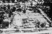
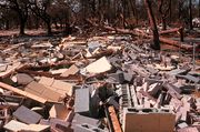
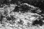
Making landfall as a Category 5 hurricane, Camille caused damage and destruction across much of the Gulf Coast of the United States. Because it moved quickly through the region, Hurricane Camille dropped only moderate precipitation in most areas. Areas near its point of landfall reported from 7 inches (180 mm) to 10 inches (250 mm).[8] The area of total destruction in Harrison County, Mississippi was 68 square miles (180 km2).[9] The total estimated cost of damage was $1.42 billion (1969 USD, $8.51 billion 2011 USD).[10] This made Camille the second-most expensive hurricane in the United States, up to that point (behind Hurricane Betsy).[11] The storm directly killed 143 people along Alabama, Mississippi, and Louisiana. An additional 153 people perished as a result of catastrophic flooding in Nelson County, Virginia and other areas nearby. In all, 8,931 people were injured, 5,662 homes were destroyed, and 13,915 homes experienced major damage, with many of the fatalities being coastal residents who had refused to evacuate.
Caribbean and Offshore Gulf of Mexico
As a developing tropical storm, Camille brought rain showers to Grand Cayman, although there were no reports of damage.[3] Stations in Cuba on the outer fringes of the storm reported winds of 50 mph (80 km/h). East of where it moved ashore, the city of Guane recorded winds of 92 mph (149 km/h), although no wind reports were taken in the landfall location. The hurricane produced up to 10 inches (255 mm) near Guane, as well as on the Isle of Pines.[3] On the Isle of Pines, the storm inflicted damage to about 100 houses.[5] Throughout Pinar del Río Province, Camille caused heavy damage,[12] primarily from river flooding;[13] about 20,000 people were left homeless in the province. Strong winds downed trees and power lines, which caused power outages eastward through the capital city of Havana. Initially, the government reported no casualties from the storm.[12] Subsequent research indicated the hurricane killed five people in the country during its passage, and damage was estimated at $5 million (1969 USD).[14]
In the days after the storm struck Cuba, the government deployed medical teams to affected regions to provide typhoid vaccine shots. Officials noted the potential for the spread of disease, due to flooding from Camille as well as previously wet conditions.[5]
In the open Gulf of Mexico, the hurricane produced wave heights of at least 70 feet (21 m), as measured by Shell Oil Company. Along the ocean floor, the storm created mudslides which lowered the ocean floor; its combination with strong waves and winds destroyed three oil platforms, including one that at the time was the deepest oil well. Property damages to the offshore oil industry were initially estimated at $100 million (1969 USD).[15]
Gulf Coast
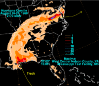
The pressure fell to 27.80 inches of mercury (941 hPa) at Garden Island. Winds gusted to 125 miles per hour (201 km/h) at Slidell as their pressure sank to 28.75 inches of mercury (974 hPa) on August 19. Almost total destruction was seen from Venice to Buras. Ostrica Lock measured a storm surge of 16 feet (4.9 m). Water overwashed U.S. Highway 90 to a depth of 10 feet (3.0 m).[16] The highest rainfall report from the state was 5.23 inches (133 mm) from Slidell.[17] Camille caused about $322 million (1969 dollars) of damage in Louisiana.[2]
Significantly worse than the Hurricane Betsy and a September 1947 hurricane, electricity went out during Camille's approach to the Mississippi coastline. United States Highway 90 flooded as its storm surge overtopped seawalls, leaving a barge along the highway in Gulfport. Fires consumed coastal communities, with the exceptions of Bay St. Louis and Waveland. Camille destroyed the antebellum Trinity Episcopal church in Pass Christian, taking 15 lives. The Dixie White House, where President Woodrow Wilson and his family once stayed, was badly damaged. In Biloxi, Mississippi, the storm surge reached the second floor of the structure.[7] The highest rainfall total recorded was 10.06 inches (256 mm) at the Mississippi Test Facility.[17] Camille caused about $950 million (1969 dollars) of damage in Mississippi.[2] Mississippi received the worst of the damage. Upon making landfall, Camille produced a 24 foot (7.3 m) storm surge. Along Mississippi's entire shore and for some three to four blocks inland, the destruction was nearly complete. The worst hit areas were Clermont Harbor, Lakeshore, Waveland, Bay St. Louis, Pass Christian, Long Beach, and the beach front of Gulfport, Mississippi City, and Biloxi.
More than 11 inches (280 mm) of rain occurred in Hancock County, and most low-lying areas were flooded with up to 15 feet (4.6 m) of water. U.S. Highway 90, which is close to the shore, was broken up in many areas, and sand and debris blocked much of it. Totals say that 3,800 homes and businesses were completely destroyed. As Camille came ashore, it passed over Ship Island, off the coast of Mississippi; Camille's strong storm surge and torrential rains literally split the island in two: the body of water between West Ship Island and East Ship Island is now called "Camille's Cut".
In addition, one of Frank Lloyd Wright's waterfront houses for W. L. Fuller, in Pass Christian, was completely destroyed by Hurricane Camille.[18] Camille had significant ecological effects in the Gulf Coast region. A barrier island chain off the coast of Mississippi and 70% of Dauphin Island were completely inundated by the storm surge from Camille.[19]
Alabama also experienced damage along U.S. Highway 90: 26,000 homes and over 1,000 businesses were wiped out completely across the state of Alabama. Camille's large circulation also resulted in a 3-to-5 foot (1-1.5 m) storm surge in Apalachicola, Florida.
The highest rainfall report received within Alabama was 6.52 inches (166 mm) two miles northeast of Fairhope.[17] Camille caused about $8 million (1969 dollars) of damage in Alabama.[2] Places farther east across the western Florida panhandle saw lesser rains, as 4.16 inches (106 mm) was measured at Pensacola Naval Air Station.[20]
The Hurricane Party

One persistent account about Camille states that a hurricane party was held on the third floor of the Richelieu Manor Apartments in Pass Christian, Mississippi, in the path of the eyewall as it made landfall. The high storm surge flooded and destroyed the building, and there was only one survivor to tell of the story of the others. Who the survivor is, how many party guests there were, and just how far the sole survivor was swept by the storm varies with the retelling. An ABC TV made for TV movie called Hurricane, starring Frank Sutton of Gomer Pyle USMC, Larry Hagman, Martin Milner, and Michael Learned, was loosely based on the supposed hurricane party. However, the site and names were changed to fictitious ones for the movie. The television show Quantum Leap carried an episode regarding the parties of Hurricane Camille and the actual hurricane itself. Survivor Ben Duckworth is quoted in Hurricane Camille: Monster Storm of the Gulf Coast as stating that the Richelieu was a designated civil defense air-raid shelter. However, their faith in the building's sturdiness was unfounded, as it was completely demolished by the storm. Twenty-three people are known to have stayed in the Richelieu Apartments during the hurricane, of whom eight died. The tale of the lone survivor and the party appears to have originated with survivor Mary Ann Gerlach.[7] Other survivors, including Duckworth and Richard Keller have expressed irritation at the story.[21][22] "The hurricane party never happened, nor were the number of deaths associated with the apartment inhabitants accurate," says Pat Fitzpatrick, Mississippi State University professor and author of Hurricanes: A Reference Handbook.[23]
Ohio Valley and West Virginia
Camille caused moderate rainfall in Tennessee and Kentucky of between 3 and 5 inches (130 mm),[24] helping to relieve a drought in the area.
Yet in West Virginia, there was flash flooding which destroyed 36 houses and 12 trailers, a total of three quarters of a million dollars in damage.[25]
Virginia
Because the hurricane was expected to quickly dissipate over land, few were prepared for the flash flooding.[26] Arriving in Virginia on the evening of August 19, Camille was no longer a hurricane, but it carried high amounts of moisture and contained sufficient strength and low pressure to pull in additional moisture.
Several places reportedly received over 8 inches (200 mm) of rain from Camille's remains, leading to significant flooding across the state. A total of 153 people lost their lives from blunt trauma sustained during mountain slides, related to the flash flooding, not drowning.[27] More than 123 of these deaths were in Nelson County. Debris avalanches occurred on hillsides with a slope greater than 35 percent.[27] In Nelson County, the number of deaths amounted to over one percent of the county's population.[28] The worst of the damage was reported in Massies Mill, Woods Mill, Roseland, Bryant, Tyro, Montebello, Lovingston, Norwood, Rockfish, and along the Davis and Muddy creeks.[27] The James and Tye rivers crested well above flood stage in many areas, including a record high of 41.3 feet (12.6 m) at Columbia, Virginia. Hurricane Camille caused more than $140 million of damage (1969 dollars) in Virginia.[2][3] Camille was considered one of the worst natural disasters in central Virginia's recorded history.[27]
The storm dropped torrential rainfall of 12 inches (300 mm) to 20 inches (510 mm), with a maximum of 27 inches (690 mm).[24] Most of the rainfall occurred in Virginia during a 3-5 hour period on August 19–20. Five (5) plus inches of rain fell near the North Fork of the Tye River in only half an hour with the grounds already saturated from previous rains.[26] Many rivers flooded across the state, with the worst being the James River in Richmond with a peak crest of 28.6 feet (8.7 m). Many rivers in Virginia and West Virginia set records for peak flood stages, causing numerous mudslides along mountainsides. In the mountain slopes between Charlottesville and Lynchburg, more than 26 inches (660 mm) of rain fell in 12 hours, but the worst was in Nelson County where 27 inches (690 mm) fell. There, rainfall was so heavy that reports were received of birds drowning in trees, cows floating down the Hatt Creek and of survivors having to cup hands around their mouth and nose in order to breathe through the deluge.
The ensuing flash floods and mudslides killed 153 people. In Nelson County alone, 133 bridges washed out, while in some places entire communities were under water.[25]
The major flooding that occurred downstream cut off all communication between Richmond and the Shenandoah Valley. Waynesboro on the South River saw eight feet of water downtown, and Buena Vista had more than five feet.
Throughout Virginia, Camille destroyed 313 houses, 71 trailers, and 430 farm buildings. 3,765 families were affected by the hurricane in the area, and total damage in the state amounted to $140.8 million (1969 USD, $747 million 2005 USD).[10][26][29][30]
Barometric pressure, winds, and other superlatives
Camille produced the seventh lowest official sea level pressure ever recorded in the Atlantic basin, at 905 hectopascals (26.7 inHg).[31] Minimum pressure at landfall in Mississippi was 909 hectopascals (26.8 inHg); the only hurricane to hit the United States with a lower pressure at landfall was the Labor Day Hurricane of 1935.[32] A reconnaissance flight indicated a pressure of 901 hectopascals (26.6 inHg),[33] but this pressure was not verified, and remains unofficial pending reanalysis. The wind speed of Camille can only be approximated, as no meteorological equipment survived the extreme conditions at landfall, but Camille is estimated to have had sustained winds of 190 miles per hour (310 km/h) at landfall, with gusts exceeding 200 miles per hour (320 km/h).[33] Before Hurricane Katrina in 2005, Camille likely had the highest storm surge measured in the United States, at over 24 feet (7.3 m).[34]
The 24-foot (7.3 m) storm surge quoted by the Army Corps of Engineers was based on high water marks inside surviving buildings, of which there were but three. Prior to the collapse of the Richelieu Apartments, Ben Duckworth shined a flashlight down a stairwell and found the water within one step of the third-story floor; this establishes a surge height of 28 feet (8.5 m) at that spot at that time. About 15 minutes later, the building collapsed and the evidence vanished with it.
In addition, Camille forced the Mississippi River to flow backwards for a river-distance of 125 miles (from its mouth to a point north of New Orleans). The river further backed up for an additional 120 miles (190 km), to a point north of Baton Rouge.[35]
In 1969 the naming conventions for hurricanes were not strictly controlled as they are today. There were only three requirements: the name had to be female (male names were not used at that time), the names had to remain in alphabetical order, and the name could not have been retired. John Hope, a meteorologist at the National Hurricane Center, had a daughter who had just graduated from high school. He added her name — Camille — to the list of storm names for the year, having no way of knowing that the storm bearing her name would become infamous.[36] Camille Hope is the wife of U.S. Rep. Jim Marshall of Georgia.
Aftermath
| Rank | Hurricane | Season | Cost (2005 USD) |
|---|---|---|---|
| 1 | "Miami" | 1926 | $157 billion |
| 2 | "Galveston" | 1900 | $99.4 billion |
| 3 | Katrina | 2005 | $81.0 billion |
| 4 | "Galveston" | 1915 | $68.0 billion |
| 5 | Andrew | 1992 | $55.8 billion |
| 6 | "New England" | 1938 | $39.2 billion |
| 7 | "Cuba–Florida" | 1944 | $38.7 billion |
| 8 | "Okeechobee" | 1928 | $33.6 billion |
| 9 | Donna | 1960 | $26.8 billion |
| 10 | Camille | 1969 | $21.2 billion |
| Main article: List of costliest Atlantic hurricanes | |||
The response after the storm involved many federal, state, and local agencies and volunteer organizations. The main organization for coordinating the federal response to the disaster was the Office of Emergency Preparedness, which provided $76 million (1969 USD, $403 million 2005 USD)[10] to administer and coordinate disaster relief programs. Food and shelter were available the day after the storm. On August 19, parts of Mississippi and Louisiana were declared major disaster areas and became eligible for federal disaster relief funds.[38] President Richard M. Nixon ordered 1450 regular troops and 800 United States Army Engineers into the area to bring tons of food, vehicles, and aircraft.[7]
Major organizations contributing to the relief effort included the Federal Power Commission, which helped fully return power to affected areas by November 25, 1969. The Coast Guard (then under the Department of Transportation), Air Force, Army, Army Corps of Engineers, Navy, and Marine Corps all helped with evacuations, search and rescue, clearing debris, and distribution of food. The Department of Defense contributed $34 million (1969 USD, $180 million 2005 USD)[10] and 16,500 military troops overall to the recovery. The Department of Health provided 4 million dollars towards medicine, vaccines and other health related needs.[38]
On Monday, the Air National Guard and those at Keesler Air Force Base airlifted patients to Jackson and other more inland locations. Volunteers searched for those injured and dead, as well as helping refugees. When many of the evacuees returned by Tuesday, Governor John Bell Williams declared martial law, blocking highways into the area and leading to a 6 p.m. to 6 a.m. curfew. The governor also opened Camp Shelby, dormitories within the University of Southern Mississippi, and the Robert E. Lee hotel to serve as shelters for those who lost homes. Sections of Bay St. Louis and Pass Christian were evacuated. Survivors were found for days after the storm, with 35 trapped by high water north of Bay St. Louis rescued on Thursday. Army engineers disposed of 25 tons of dead animals, mostly cows, during the week following Camille. One week after the storm, Keesler-based air planes sprayed malathion at low altitudes to kill the thriving insect population. Martial law would be lifted on August 27. The federal and state military presence would continue for several weeks. During the evening of September 8, President Nixon visited the Biloxi-Gulfport Regional Airport and gave a speech to elevate the spirits of local residents struggling with the storm's aftermath. During the rebuilding process, stricter building codes were enforced by local governments. In 1973, hurricane hunters and their associated reconnaissance aircraft relocated to Keesler Air Force Base when their previous headquarters at Ramey, Puerto Rico, closed.[7]
Long-term redevelopment was overseen by the Department of Commerce, which contributed $30 million (1969 USD, $159 million 2005 USD)[10] towards planned and coordinated redevelopment of affected areas.
The devastation of Camille inspired the implementation of the Saffir-Simpson Hurricane Scale. After the storm, many Gulf Coast residents commented that hurricane warnings were not clear enough in conveying the expected intensity of the coming storm. The Saffir-Simpson scale offered a much more concise statement of storm intensity than barometric pressure and wind-speed measurements, and veterans of previous hurricanes could analogize the power of the approaching storm to those they had experienced.[39]
In a 1999 report on Hurricane Camille sponsored by the NOAA Coastal Services Center, the authors concluded: "With Camille, the preparations for the event and the response were based on processes put in place long before the storm made landfall. Coordination between government agencies as well as with state and local officials was enhanced because of preexisting plans."[38]
One small compensation was that recovery from flood damage in Nelson County, Virginia led to the discovery of the Ginger Gold apple in the orchards of Clyde Harvey.[40]
Retirement
Due to the major destruction and death in much of the Southern United States, the name Camille was retired after the 1969 season,[41] and will never again be used for an Atlantic or Gulf hurricane or tropical storm. A replacement name was never chosen, as a new ten-year list of names was created for the 1971-1980 Atlantic hurricane seasons.[42]
Comparisons to Hurricane Katrina
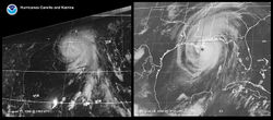
Although Hurricane Camille and Hurricane Katrina took different paths, they reached the same section of the coast of Mississippi with similar destructive effects. Camille intensified more rapidly than Katrina, and unlike Katrina, Camille maintained status as a Category 5 hurricane until landfall. However, the observed minimum pressure in Katrina was slightly lower. Both hurricanes shared the common aspect of undergoing periods of rapid intensification.[43] The size of Camille's radius of maximum wind was less than one-third that of Katrina, more similar to the intense but small Hurricane Andrew; consequently, unlike Katrina, Camille caused little damage in New Orleans, Louisiana.[44] The area of hurricane-force winds within Camille was just over two-thirds the size of Hurricane Katrina. Both storms were moving at a similar forward motion at the time of landfall. Although Camille's wind speed at landfall was higher, Katrina's storm surge exceeded Camille's storm surge at all known locations due to its greater size.[45]
In Literature, On Stage and Television
In 2008, Amherst, Virginia-based Endstation Theatre premiered an original play, "The Bluest Water: A Hurricane Camille Story" (by playwright Jason Chimonides), as part of its inaugural Blue Ridge Summer Theatre Festival on the campus of Sweet Briar College.[46] While the play was partly historical fiction (featuring contrived characters experiencing or remembering the actual events of Hurricane Camille), many characters' stories or dialog were composites of true accounts or testimonials from Nelson County, Virginia (most notably Massies Mill, Virginia, the Tye River, and Davis Creek) and the surrounding areas. The play was revived in the festival's second year (2009), in conjunction with the Nelson County Historical Society's observation of the 40th Anniversary of Camille.[47]
On the October 2, 1991 episode of the NBC series Quantum Leap titled "Hurricane" (Season 4, Episode 3) the main character, Sam Beckett, leaps into Archie Necaise, a small-town sheriff in the middle of Hurricane Camille. He must keep his host's girlfriend from being killed in the storm. Hurricane Camille is the backdrop of the story.
Without Remorse by Tom Clancy opens with the demolition of an oil rig damaged during Camille.
See also
- List of Atlantic hurricane records
- List of Category 5 Atlantic hurricanes
- List of wettest known tropical cyclones in Virginia
- List of retired Atlantic hurricane names
References
- ↑ Ed Rappaport (1997-04-22). "Deadliest US Hurricanes". National Hurricane Center. http://www.nhc.noaa.gov/pastdeadlyapp1.shtml?. Retrieved 2006-05-28.
- ↑ 2.00 2.01 2.02 2.03 2.04 2.05 2.06 2.07 2.08 2.09 2.10 2.11 2.12 R.H. Simpson, Arnold L. Sugg (April 1970). "The Atlantic Hurricane Season of 1969" (PDF). Monthly Weather Review 98 (4). http://www.aoml.noaa.gov/hrd/hurdat/mwr_pdf/1969.pdf. Retrieved 2009-02-28.
- ↑ 3.0 3.1 3.2 3.3 3.4 3.5 3.6 3.7 3.8 3.9 "Hurricane Camille Preliminary Report" (PDF). U.S. Department of Commerce. September 1969. http://www.nhc.noaa.gov/archive/storm_wallets/atlantic/atl1969-prelim/camille/TCR-1969Camille.pdf. Retrieved 2009-02-28.
- ↑ Hurricane Research Division (2008). "Atlantic Hurricane Best Track (1851-2007)". National Oceanic and Atmospheric Administration. http://www.aoml.noaa.gov/hrd/hurdat/easyhurdat_5107.html. Retrieved 2009-03-02.
- ↑ 5.0 5.1 5.2 Staff Writer (1969-08-17). "Cuba Faces Big Problem From Storm". Associated Press. The Progress-Index. http://www.thehurricanearchive.com/Viewer.aspx?img=100366666_clean&firstvisit=true&src=search¤tResult=5¤tPage=0. Retrieved 2009-03-04.
- ↑ Associated Press (August 15, 1969). "Hurricane Camille Approached Cuba Today". The Prescott Courier. http://news.google.com/newspapers?id=-x4LAAAAIBAJ&sjid=Z1ADAAAAIBAJ&pg=3458,1128026&dq=hurricane+camille. Retrieved 2009-03-02.
- ↑ 7.0 7.1 7.2 7.3 7.4 Charles L. Sullivan (1985). Hurricanes of the Mississippi Gulf Coast: 1717 to Present. Gulf Publishing Company, Inc.: pp. 93-118.
- ↑ David M. Roth (2007-10-30). "Hurricane Camille Rainfall Graphic". Hydrometeorological Prediction Center. http://www.hpc.ncep.noaa.gov/tropical/rain/camille1969filledrainblk.gif. Retrieved 2007-12-25.
- ↑ Harrison County Library System (2009-07-14). "Harrison County Camille Information". http://www.harrison.lib.ms.us/library_services/camille.htm. Retrieved 2009-12-26.
- ↑ 10.0 10.1 10.2 10.3 10.4 "The Inflation Calculator". http://www.westegg.com/inflation/. Retrieved 2006-06-18.)
- ↑ Chris Landsea (2007). "The Deadliest, Costliest, and Most Intense United States Hurricanes from 1900 to 2000 (And Other Frequently Requested Hurricane Facts)". Atlantic Oceanographic and Meteorological Laboratory. http://www.aoml.noaa.gov/hrd/Landsea/deadly/Table3.htm. Retrieved 2009-12-26.
- ↑ 12.0 12.1 Associated Press (1969-08-16). "Florida Braces for Big Blow". The Kingston Gleaner. http://www.thehurricanearchive.com/Viewer.aspx?img=31828318_clean&firstvisit=true&src=search¤tResult=4¤tPage=0. Retrieved 2009-03-02.
- ↑ Associated Press (1969-08-18). "Hurricane Smashes Mississippi Coast". http://www.thehurricanearchive.com/Viewer.aspx?img=58905293_clean&firstvisit=true&src=search¤tResult=0¤tPage=0. Retrieved 2009-03-10.
- ↑ Roger A. Pielke Jr., et al. (August 2003). "Hurricane Vulnerability in Latin America and The Caribbean: Normalized Damage and Loss Potentials" (PDF). National Hazards Review. http://www.aoml.noaa.gov/hrd/Landsea/NHR-Cuba.pdf. Retrieved 2009-03-02.
- ↑ Minerals Management Service Gulf Coast Region (2004-08-03). "History of the Offshore Oil and Gas Industry in Southern Louisiana Interim Report: Volume I: Papers on the Evolving Offshore Industry". United States Department of the Interior. http://www.gomr.mms.gov/homepg/regulate/environ/studies/2004/2004-049.pdf. Retrieved 2009-03-10.
- ↑ David M. Roth (1998). Louisiana Hurricane History: Late 20th Century (continued). National Weather Service Southern Region Headquarters. Retrieved on 2009-03-13.
- ↑ 17.0 17.1 17.2 David M. Roth (2009). Tropical Cyclone Rainfall for the Gulf Coast. Hydrometeorological Prediction Center. Retrieved on 2009-03-13.
- ↑ "Frank-Lloyd-Wright.com, FLW Designs (2005)". pp. "Enduring Legacy" (bottom).. http://www.frank-lloyd-wright.com/. Retrieved 2006-09-04.
- ↑ Robert Morton, Kristy Guy, and Anne Whitko, Tiffany Pascoe, and Heather Hill (2007). Morphological Impacts of Hurricane Camille (1969) On Barrier Islands of Mississippi and Western Alabama. United States Geological Survey. Retrieved on 2009-03-13.
- ↑ David M. Roth (2009). Tropical Cyclone Rainfall in Florida. Hydrometeorological Prediction Center. Retrieved on 2009-03-13.
- ↑ "UPM Philip Hearn Interview". University Press Mississippi. http://www.upress.state.ms.us/features/camille/interview.html. Retrieved 2006-05-28.
- ↑ Kat Bergeron. "Correcting the facts and debunking the myths of Camille". The Sun Herald. http://www.hurricanealley.net/camillemyth.htm. Retrieved 2006-05-28.
- ↑ ""Hurricane Reference Guide". Mississippi State University. http://web.archive.org/web/20050330120739/http://www.ur.msstate.edu/news/stories/2004/hurricanebook.asp. Retrieved 2005-03-30.
- ↑ 24.0 24.1 David M. Roth (2007-10-31). "Hurricane Camille". Hydrometeorological Prediction Center. http://www.hpc.ncep.noaa.gov/tropical/rain/camille1969.html. Retrieved 2007-11-03.
- ↑ 25.0 25.1 United States Department of Commerce (1969). "Hurricane Camille August 14–22, 1969" (PDF). Environmental Science Services Administration. http://www.nhc.noaa.gov/archive/storm_wallets/atlantic/atl1969-prelim/camille/TCR-1969Camille.pdf. Retrieved 2008-03-23.
- ↑ 26.0 26.1 26.2 "1969 Monthly Weather Review" (PDF 17.8 MB). NOAA. http://www.aoml.noaa.gov/general/lib/lib1/nhclib/mwreviews/1969.pdf. Retrieved 2006-05-28.
- ↑ 27.0 27.1 27.2 27.3 Garnett P. Williams and Harold P. Guy. Erosional and Depositional Aspects of Hurricane Camille in Virginia, 1969. United States Government Printing Office, 1973, pp. 1.
- ↑ Divine wind: The History and Science of Hurricanes. New York, NY: Oxford University Press US. 2005. pp. 205–211. ISBN 0-19-514941-6. http://books.google.com/?id=IHALBxIYBGMC&pg=PA205&dq=Hurricane+Camille.
- ↑ United States Department of Commerce (1969). "Hurricane Camille August 14–22, 1969" (PDF). Environmental Science Services Administration. http://www.nhc.noaa.gov/archive/storm_wallets/atlantic/atl1969-prelim/camille/TCR-1969Camille.pdf. Retrieved 2009-12-26.
- ↑ Virginia Department of Emergency Management (2009). "Virginia's Weather History". http://www.vaemergency.com/newsroom/history/hurricane.cfm. Retrieved 2006-05-28.
- ↑ National Hurricane Center (2009-06-06). "Atlantic Hurricane Database". National Oceanic and Atmospheric Administration. http://www.nhc.noaa.gov/tracks1851to2009_atl_reanal.txt. Retrieved 2009-12-26.
- ↑ Eric S. Blake, Edward N. Rappaport, and Chris Landsea. The Dealiest, Costliest, and Most Intense United States Tropical Cyclones From 1851 to 2006 (and other frequently requested hurricane facts). Retrieved on 2008-03-19.
- ↑ 33.0 33.1 "NWS Jackson Special Weather Summary". NOAA. http://www.srh.noaa.gov/jan/msnws8.html. Retrieved 2006-05-28.
- ↑ "Hurricane Resources". US Army Corps of Engineers. http://www.hq.usace.army.mil/history/Hurricane_files/Hurricane.htm. Retrieved 2006-05-28.
- ↑ Howard, Judith A.; Zebrowski, Ernest (2005). Category 5: The Story of Camille. Ann Arbor: University of Michigan Press. pp. 109. ISBN 0472115251.
- ↑ "John Hope a North Georgia Notable". Golden Ink. http://ngeorgia.com/people/hope.html. Retrieved 2006-05-29.
- ↑ Pielke, Roger A., Jr.; et al. (2008). "Normalized Hurricane Damage in the United States: 1900–2005" (PDF). Natural Hazards Review 9 (1): 29–42. doi:10.1061/(ASCE)1527-6988(2008)9:1(29). http://forecast.mssl.ucl.ac.uk/shadow/docs/Pielkeetal2006a.pdf.
- ↑ 38.0 38.1 38.2 Roger A. Pielke, Jr., Chantal Simonpietri, and Jennifer Oxelson (1999-07-12). "Thirty Years After Hurricane Camille: Lessons Learned, Lessons Lost". University of Colorado. http://sciencepolicy.colorado.edu/about_us/meet_us/roger_pielke/camille/report.html. Retrieved 2009-12-26.
- ↑ Willie Drye (2005-12-20). ""Category Five": How a Hurricane Yardstick Came to Be". National Geographic. http://news.nationalgeographic.com/news/2005/12/1220_051220_saffirsimpson.html. Retrieved 2006-07-30.
- ↑ "Hurricane Camille Leaves a New Apple in Nelson C." Charlottesville Daily Progress, September 18, 1992
- ↑ National Hurricane Center (2009). "Retired Hurricane Names Since 1954". National Oceanic and Atmospheric Administration. http://www.nhc.noaa.gov/retirednames.shtml. Retrieved 2009-09-13.
- ↑ "Annual Hurricane Supplement:Ten Year List of Storm Names". Naples Daily Times (The Hurricane Newspaper Archive). 1972-06-30. http://www.thehurricanearchive.com/Viewer.aspx?img=76518933_clean&firstvisit=true&src=search¤tResult=1¤tPage=0. Retrieved 2009-10-10.
- ↑ Jay S. Hobgood (2006). 16C.7: A comparison of hurricanes Katrina (2005) and Camille (1969). American Meteorological Society's 27th Conference on Hurricanes and Tropical Meteorology. Retrieved on 2009-03-13.
- ↑ Stefan Bechtel (2006). Roar of the Heavens. Stefan Bechtel, pp. 279. ISBN 9780806527062. Retrieved on 2009-03-13.
- ↑ Hermann M. Fritz, Chris Blount, Robert Sokoloski, Justin Singleton, Andrew Fuggle, Brian G. McAdoo, Andrew Moore, Chad Grass, Banks Tate (2007). Hurricane Katrina storm surge distribution and field observations on the Mississippi Barrier Islands. Estuarine, Coastal and Shelf Science Volume 74, pp. 14-20. Retrieved on 2009-03-13.
- ↑ Endstation Theatre (Amherst, VA) official website
- ↑ Nelson County Historical Society official website
Further reading
- Bechtel, Stefan (2006). Roar Of The Heavens: Surviving Hurricane Camille. New York: Citadel Press. ISBN 0806527064.
- Hearn, Philip D. (2004). Hurricane Camille: Monster Storm of the Gulf Coast. Jackson, MS: Univ. Press of Mississippi. ISBN 1578066557.
External links
- Harrison County Library's Camille Page
- Thirty Years After Hurricane Camille: Lessons Learned, Lessons Lost, Roger A. Pielke, Jr., Chantal Simonpietri, and Jennifer Oxelson, July 12, 1999.
- Track of Camille's eye at landfall
- Storm surge profile
- Post-Storm Report on Camille
- The story of Harbour Oaks Inn
- Radar image of Camille
|
||||||||||||||||||||
|
||||||||||||||||||||||||||
|
|
||||||||||||||||||||||||||||||||||||